Archaeological discoveries at 81–97 Portswood Road
(formerly Lowmans Bakery, Wickes and now Fullerton Place)
INTRODUCTION
Archaeological works were carried out by the Archaeology Unit of Southampton City Council at the former Wickes store, 81–97 Portswood Road, during 2008 and 2009 before the construction of the Fullerton Place Estate. This site north of Bevois Mount provided valuable clues of local activities carried out in prehistoric, Romano-British and post-medieval times.
PREHISTORIC AND ROMANO-BRITISH
By Amanda Steart
The area of Portswood and Bevois Mount has long been known for prehistoric and Roman activities. A prehistoric burial mound probably existed to the south, on Bevois Hill, in the grounds of Bevois Mount House. Dr John Speed in 1770 had noted that the mound was possibly located where the summer house stood as “in digging the foundations of the summer house a human skeleton, with bones of a large size, was found. No search was made for the rest of the skeleton” (Davies 1883, 6). Speed also mentions Roman coins had also been found at the top of Bevois Hill but their location were not disclosed.
To the south-east of the site and east of Bevois Mount, three Roman graves containing small jars were discovered during the making of Lawn Road in the 1850s. Roman cremation urns were also found in the 19th century at Tennyson Road. Another Roman settlement dating to the 1st century AD was found at 20 Eastfield Road, St Dcnys, north-east of Bevois Mount, with evidence of iron working activities at the site (Smith 2002). Additionally, within the intertidal mudflats of the River Itchen between Clausentum and St Denys, to the rear of 140-150 Priory Road, were found two Roman piers made of oak piles and a revetment.
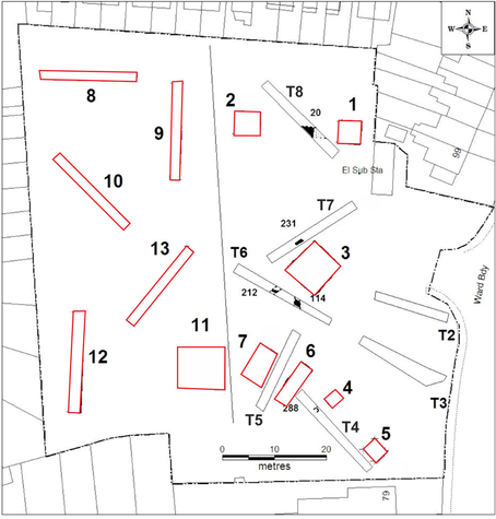
Plan showing the trenches of 2008 excavation (black) and 2009 excavation (red)
|
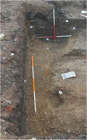
Detail of Ditch 167 in Trench 1 (2009), looking west
|
During the 2008 excavation of the site nine worked flint flakes that suggest prehistoric activity in the area. There were also three field boundaries were found in Trenches T6 and T8 that were dated by finds of pottery sherds and ceramic building material (brick and tile) from the Romano-British period. In 2009 two Romano-British ditches were found with one containing large sherds of a Dressel 20 olive oil amphora.
Pottery found mostly dated from the second half of the Romano-British period. Storage jars, cooking pots, bowls and beakers are all present, suggesting a standard domestic site. Dating evidence of these finds suggest activity or occupation during the late 3rd–4th century AD.
One interesting find is a fragment of sandstone that was probably derived from a Roman roof tile. Roof tiles in this stone are not common finds in the Southampton area but a few fragments are known from the Clausentum site found across the Itchen at Bitterne Manor. Additionally, fragments of Romano-British ceramic building materials were recovered that were produced at Curbridge to the west.
Overall, the Romano-British finds suggests the presence of a substantial building with masonry walls, possibly sleeper walls to support a timber framed super-structure, and a well-built tiled roof. It might have had under floor heating too as there was found a large fragment of a highly fired tile suitable for capping pilae tiles in a hypocaust system. The horizontal features found at the site were probably drainage ditches and field boundaries associated with organised agriculture. This was possibly a farmstead, near the northeast of the site, and was occupied and farmed at that time to, perhaps, provide food for the large Roman military contingent based at Clausentum on the opposite site of the Itchen.
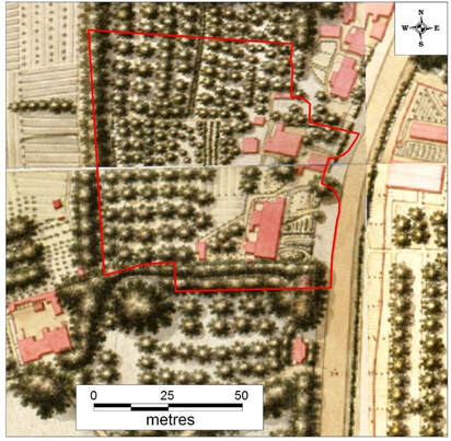 The Royal Engineers’ Map of 1846 with the site outline (red)
MEDIEVAL, POST-MEDIEVAL TO PRESENT
By Kenneth Lymer
Excavations from 2008 and 2009 at 81–97 Portswood Road found no medieval features but residual late medieval finds of pottery and ceramic building material that were recovered from later deposits. The mid-18th century to the late 19th century is represented by finds of pottery, glass, clay pipe fragments, limestone rubble, brick, tile, slate, lime mortar, coal, charcoal and brick structures.
An accurate surveyed map of the Manor of Portswood, dated 1658, shows the 81–97 Portswood Road site was once an area of two fields. These were divided by an east-to-west boundary and belonged to Thomas Gill. Excavations recovered bricks in Trench T5 thought to belong to a house shown on the 1658 map.
The Royal Engineers’ map of 1846 shows houses were built on the east part of the site. Most of them survived as numbers 83, 85, 93 and 95 until the second-half of the 20th century.
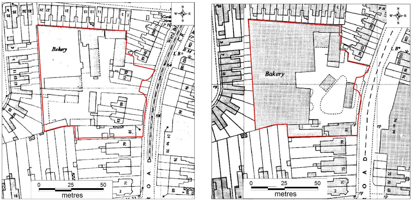
Left: The site circa 1948, showing the bakery. Right: The site circa 1966, showing the final extent of the bakery.
The west part of the site was an orchard in 1846 that lasted until the 1930s, when it was developed by Lowmans’ Bakery. The bakery address and street frontage was at number 91. Expansion of the bakery in the 1960s resulted in the demolition of numbers 83–89, 93 and 95.
In Trenches T2 and T7 there was evidence for ground clearance carried out during the expansion of the former bakery, while services associated the bakery were found in Trenches T2 and T4. A concrete foundation of the bakery was found in Trench T5.
The bakery closed in the 1980s and the site, together with the site of number 81, was redeveloped as Wickes’ builders’ merchants. This then, in turn, was knocked down in 2008 for the construction of the Fullerton Place Estate.
CONCLUSION
Overall, the Southampton City Council Archaeology Unit’s excavations importantly revealed traces of prehistoric activities (flints) and evidence of a Romano-British farmstead connected to the Roman fort of Clausentum close to Bevois Mount. It also has provided us with valuable clues in post-medieval times starting with the build up of the area at 81–97 Portswood Road from the rural 18th-century setting to the later 19th century residential development and commercial redevelopment of the site by Lowman’s Bakery in the 20th century.
References
Portions of this article was based on information courtesy of Dr Andy Russel of the Southampton Archaeology Unit.
Davis, J.S. 1883 A History of Southampton. Gilbert & Co., Southampton.
Smith, A.P. 2002 A Roman settlement and iron working site at St Denys, Southampton (SOU 981). Proceedings of the Hampshire Field Club Archaeological Society 57, 30-37.
Southampton Archaeology Unit, Archaeological Evaluation Excavation at 81–97 Portswood Road, Southampton, SOU 1518, (unpublished) 2008.
Southampton Archaeology Unit, Archaeological Excavation and Watching Brief at 81–97 Portswood Road, Southampton, SOU 1518, (unpublished) 2010.
